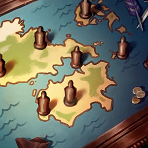
There was a recently released icon teasing the Runeterra map:
https://vignette.wikia.nocookie.net/leagueoflegends/images/2/2a/Runeterra_Map_profileicon.png/revision/latest?cb=20180706201411
You can get an idea of where the factions reside, northeastern Valoran we have Noxus, to the west, Demacia, up north I imagine is the Freljord, the stretch of land connecting north and south Valoran, we have Piltover/Zaun, down south we have Shurima and its outlying cities (Icathia, etc.), to the west of that I imagine is Mt. Targon and to the far east of southern Valoran the lush green spot, I imagine that's the Kumungu Jungle.
Outside the continent of Valoran, we have Ionia up in the northeast and south of that, we have the island of Bilgewater. If you look very, very closely at the southeastern side of the map, you can see the smallest bit of the little figure that represents where the Shadow Isles reside.
I don't think that Bandle City and the Glade will be seen on the map because it has been hinted that those places exist only in the 'spirit realm'. I believe that the only reason why we have yordles in Runeterra is because of how they can traverse the spirit realm and the physical realm of Runeterra.